The Early Paleocene Turtle Mountain microflora
Background
Turtle Mountain is a plateau 600 m above sea level, 90 m to 120 m above the surrounding countryside, extending 32 km from north to south and 64 km from east to west along the Manitoba-North Dakota border. It is the only area in Manitoba where Cenozoic sediments can be found in outcrop. Early Paleocene marine shales and terrestrial mudstones and coals are found exposed in stream-banks and ravines on the western flank of Turtle Mountain, along Hwy 21 (see map below: from Patel et al. 2022).
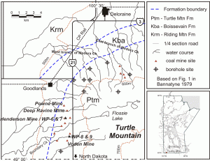 Manitoba’s only commercial coal operations were developed following discovery of lignite near Turtle Mountain in 1879. Production began in 1883 with the opening of the Lennox mine and continued intermittently at the Voden, McArthur, McKay, and Manitoba Coal Company mines until 1908. Coal was extracted from outcrops in ravines and from shallow shafts. Its availability spurred settlement while offering supplementary income to local farmers. The construction of railways introduced competitive Saskatchewan coal and commercial production around Turtle Mountain was suspended. Interest in mining was revived during the Depression because Turtle Mountain lignite was cheaper than higher grades. At its peak, annual production of the McArthur, Henderson, Deep Ravine, Salter, Powne, and Deloraine Coal Company mines averaged over 1000 tons each. The wartime labour shortage and changed economic conditions forced the last mine to close in 1943. [excerpted from MB Heritage and Bannatyne 1978 & 1979].
Several Paleocene macrofloras are relatively well known from the Williston Basin in southern Saskatchewan, associated with lignite seams and mudstones in the Cypress Hills and also along the Souris River near Estevan (McIver 1999; Frank & Bend 2004). However, very little is known about plant fossils of this age from further east. Conifer shoots of Sequoia (redwood), Taxodium (bald or swamp cypress) and Cladophlebis (indeterminate) from outcrop of the Goodlands Member of the Turtle Mountain Fm. near Goodlands in south-western MB, and rare leaf impressions collected from a single exposure of the Peace Garden Mbr. (Bamburak, 1978 & pers. comm., 2005 & 2010) are the sole record of Paleocene age plant macroflora from MB. These fossils were associated with the Paleocene lignites formerly mined in the Turtle Mountain area (Wickenden 1945; Bamburak 1978). Since their original discovery, the southwest Manitoba plant fossil floras have remain unstudied, although a core intersecting these sediments was studied for a pollen-based stratigraphic study that only provided limited palaeoenvironmental inference (Braman & Sweet 1999; Braman 2018). Lignites from SK similar to those in the Goodlands Member have yielded plant leaf cuticle (McIver 1999) and/or had their palaeoenvironment reconstructed using fossil spores and pollen (Frank & Bend 2004).
The Early Paleocene coals from the Souris Mire in Saskatchewan were interpreted by Frank & Bend (2004) as being formed by cycles of different plant communities, culminating in a conifer-dominated swamp forest containing ferns, shrubby angiosperms and relatives of the living swamp cypress (Taxodium spp., as the TCT pollen-type) of the southeast USA.
Research by BU team members.
 In 2005 and 2007, samples of lignite from the Goodlands Mbr were collected by David Greenwood and his undergraduate palaeobotany class from stream-bank exposures and from the abandoned Henderson Mine near Goodlands MB, and sent to Art Sweet of the GSC in Calgary for processing. The microflora from the stream-bank samples was assigned by Art Sweet to the Early Paleocene Tricolporopollenites kruschii Zone of Braman and Sweet (1999). The microflora was studied by Greenwood Lab Honours students Mackenzie Desautels (2010-2011) and Nidhi U. Patel (2020-2021), using facilities in the Greenwood Lab. to:
- determine the stratigraphic relationship of each of the sample localities (working with Art Sweet† and Jen Galloway of the GSC Calgary);
- document the spore-pollen microflora;
- compare the Turtle Mountain microflora to similar age microfloras from the Williston Basin and adjoining areas in western Canada; and
- reconstruct the Early Paleocene vegetation and environment of these coals.
Based on the presence of diagnostic dinoflagellates, most of the younger Peace Garden member is marine in origin, as are most of the shales and sandstones of the coal-bearing Goodlands member (Kurita & McIntyre, 1995; McIntyre, 1999). Rare leaf impressions have been collected from a single exposure of the Peace Garden Mbr (Bamburak, 1978 & pers. comm., 2005 & 2010), on the NW flank of Turtle Mountain, in the headwaters of West Medora Creek, indicating some shallow inshore facies. The coals and associated mudstones represent transient terrestrial swamp environments at the margins of of an intercontinental seaway. Palynological work on the coals (Sweet, 2005; Patel et al. 2022) has identified numerous mosses (e.g. Sphagnum spp.), ferns and other pteridophytes (incl. Lycopodium, Gleicheniaceae, Polypodiaceae and Schizeaceae), Sequoia, Taxodium relatives (as TCT pollen), Pinaceae (bisaccates, likely part of the regional pollen rain), Ginkgo, Juglandaceae (walnut-hickory family, as Caryapollenites and Momipites spp.), Betulaceae (birch family, incl. Alnus spp.), Ericaceae, Ulmaceae and Aquifoliaceae (as Ilexpollenites sp.). Some of these are illustrated below.
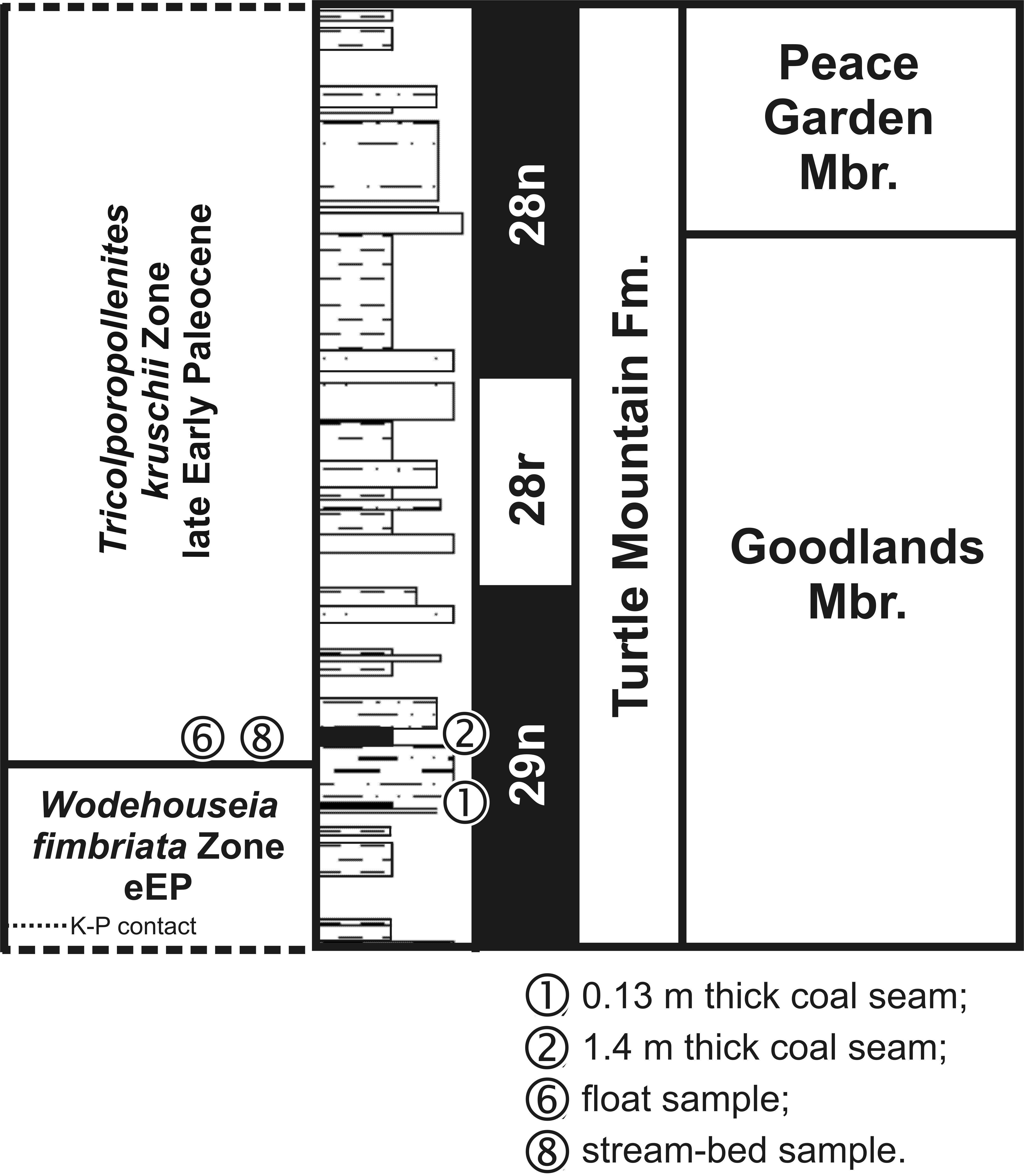
In his assessment of the palynofloras, Art Sweet noted that the presence of Momipites microfoveolatus, Tricolporopollenites kruschii (= Margocolporites cribellatus), and rare occurrences in some samples of Wodehouseia fimbriata in the palynoflora were consistent with an Early Paleocene age assignment (Sweet 2005). Some samples were assigned by Sweet (2005) to the late Early Paleocene Tricolporopollenites kruschii Zone of Braman and Sweet (1999; see also Braman 2018). A truncated stratigraphic diagram can be found here. These results were corroborated by the work of Desautels and Patel (Patel et al. 2022).
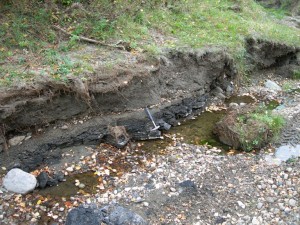
A short section was cut near the creek exposure on a tributary of Boundary Creek in September 2007 near the original sample sites, and samples processed at the GSC in Calgary. This section revealed 2 small coal seams, separated by a mudstone unit, with the basal coal (at creek-bed level) quite woody. Palynological analysis of these samples is now published (Patel et al., 2022).
As part of Mackenzie Desautels’ Honours thesis project, we revisited a number of old coal-mining sites with Jim Bamburak formerly of the MB Geological Survey. A total of three adits were found, representing the Deloraine Coal Co. mine (on the East Branch of Medora Creek), and a site on a tributary of Boundary Creek that may be the Powne or Deep Ravine mine. An exposure of the Peace Garden member, which is stratigraphically higher than the Goodlands member, was also visited. This exposure has previously yielded leaf impressions. The sites were palynologically analyzed as part of Mackenzie’s and Nidhi’s research, assisted by Art Sweet (deceased) and Jen Galloway of the GSC Calgary.
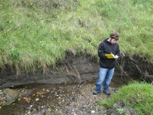
Left: Former Honours student, Mackenzie Desautels, at outcrop of Goodlands Mbr Paleocene coals, September 2010.
Acknowledgements
Initial funding for this project was provided by the BU Research Committee, with ongoing funding provided by a NSERC Discovery Grant to Dr. Greenwood. Laboratory facilities used for this project were provided under funding from NSERC and under the CFI New Opportunities fund and supported by the Manitoba Research & Innovation Fund.
We thank Jim Bamburak formerly of the MB Geological Survey and both Dr. Rong-Yu Li and Peter Adamo (formerly of the BU Geology Dept.) for their assistance in finding the coals in outcrop, and the BU Palaeobotany classes of 2005, 2007, and the class of 2009. Initial pollen counts were provided by Sweet (2005) and K. Stouffer (unpubl.), the latter during a NSERC USRA project with Dr. Greenwood in 2008. The palynoflora of the section was thoroughly documented by Nidhi Patel for her Honours thesis in Biology at BU. Pollen photography was in part by C.L. Greenwood, Palynology Research Assistant in the Greenwood Lab., but principally by Nidhi Patel as part of her Honours thesis.
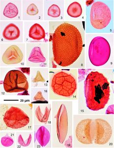
Examples of fossil moss and pteridophyte spores and gymnosperm pollen from the Goodlands Mbr, Turtle Mtn Fm, MB (Patel et al. 2022).
All images taken on either an Olympus BX41 or BX51 microscope in the BU Greenwood Research Laboratory.
Funding from: 

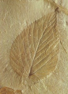
Fossil leaf from Turtle Mountain Formation (Peace Gardens Mbr?).
The leaf is likely Ulmus (elm).
Photos © 2007 by C.L. Greenwood, D.R. Greenwood, M. Desautels, and N.U. Patel.
Background:
NB: Hyperlinks take you to the ‘free to view’ abstract of the article on the NRC Press website. Access to the full article depends on your personal or institutional access rights or subscriptions to NRC Press online materials.
Bamburak, J.D. 1978. Stratigraphy of the Riding Mountain, Boissevain and Turtle Mountain formations in the Turtle Mountain area, Manitoba. Province of Manitoba, Department of Mines, Resources and Environmental Management, Geological Report 78-2.
Bannatyne, B.B. 1978. Summary of available data on lignite deposits. Turtle Mountain, Manitoba (with a note on other occurrences in the Province). Manitoba Mineral Resources Division. Economic Geology Report 77/1, 55 p.
Bannatyne, B.B. 1979. Lignite in Manitoba. Manitoba Mines & Energy, Educational Series ES79-1. 7 pp.
Braman, D.R. 2018. Terrestrial palynostratigraphy of the Upper Cretaceous (Santonian) to lowermost Paleocene of southern Alberta. Palynology, 42(1): 102–147.
Braman, D.R. and Sweet, A.R. 1999. Terrestrial palynomorph biostratigraphy of the Cypress Hills, Wood Mountain, and Turtle Mountain areas (Upper Cretaceous-Paleocene) of western Canada. Canadian Journal of Earth Sciences, 36: 725-741.
Braman, D.R., Sweet, A.R., and Lerbekmo, J.F. 1999. Upper Cretaceous – lower Tertiary lithostratigraphic relationships of three cores from Alberta, Saskatchewan, and Manitoba, Canada. Canadian Journal of Earth Sciences, 36: 669-683.
Catuneanu, O. and Sweet, A.R. 1999. Maastrichtian-Paleocene foreland-basin stratigraphies, western Canada: a reciprocal sequence architecture. Canadian Journal of Earth Sciences, 36: 685-703.
Frank, M.C. and Bend, S.L. 2004. Peat-Forming History of the Ancestral Souris Mire (Paleocene), Ravenscrag Formation, Southern Saskatchewan, Canada. Canadian Journal of Earth Sciences, 41: 307-322.
Kurita, H. and McIntyre, D.J. 1995. Paleocene dinoflagellates from the Turtle Mountain Formation, southwestern Manitoba, Canada. Palynology, 19: 119-136.
Lerbekmo, J.F. 1999. Magnetostratigraphy of the Canadian Continental Drilling Project Cretaceous-Tertiary (K-T) Boundary Project core holes, western Canada. Canadian Journal of Earth Sciences, 36: 705-715.
McIntyre, D.J. 1999. Campanian to Paleocene dinoflagellate assemblages from the Turtle Mountain core hole, Manitoba, western Canada. Canadian Journal of Earth Sciences, 36: 769-774.
McIver, E.E. 1999. Paleobotanical evidence for ecosystem disruption at the Cretaceous-Tertiary boundary from Wood Mountain, Saskatchewan, Canada. Canadian Journal of Earth Sciences, 36: 775-789.
Patel* N, Greenwood DR, Galloway JM, Greenwood CL & Desautels M. 2022. A reconstruction of the early Paleocene palaeovegetation of Turtle Mountain, southwestern Manitoba, Canada. Palynology, 46(4): 1–16, doi:10.1080/01916122.2022.2064555 open access
Sweet, A.R. 2005. Applied research report on 4 Early Paleocene samples from Turtle Mountain Formation outcrops located on the west flank of Turtle Mountain, (NTS62F/02), south western Manitoba. GSC Calgary Report Number 12-ARS-2005.
Wickenden, R.T.D. 1945. Mesozoic stratigraphy of the eastern plains, Manitoba and Saskatchewan. Geological Survey of Canada, Memoir 239.