Practice Questions – Term Test 1
Note: This is a random sample of the type of multiple choice questions that will be on the exam. None of these questions may actually appear on the exam. Do not use this as your primary means of studying or otherwise preparing for this test.
1) The main methodology governing geographic inquiry
A) is behavioral analysis
B) involves spatial analysis
C) uses chronological organization
D) is field work
E) is reasoning systematics
Answer: B
2) The scientific method is described by which of the following?
A) the application of complex theory
B) a relation to procedures developed by Galileo
C) the development of hypotheses for testing and prediction
D) educated guesswork
E) probability theory and estimation
Answer: C
3) Which of the following is an example of a system?
A) a leaf
B) a river drainage basin
C) a midlatitude cyclonic storm
D) All of these are examples of systems
E) None of these are examples of systems
Answer: D
4) Which of the following is true of models?
A) they are concrete representations of the world
B) they are exact representations of the world
C) they are simplified representations of the world
D) they cannot be used to measure real world phenomena
E) because they are small, they cannot accurately reflect reality
Answer: C
5) According to the text, the three inorganic Earth realms are the
A) thermosphere, lithosphere, heterosphere
B) hydrosphere, lithosphere, and atmosphere
C) atmosphere, geoid, and homosphere
D) stratosphere, magnetosphere, and troposphere
E) biosphere, lithosphere, and atmosphere
Answer: B
6) The science that specifically attempts to determine Earth’s shape and size by surveys and mathematical means is called
A) geography.
B) geology
C) cartography
D) astronomy
E) geodesy
Answer: E
7) A parallel of latitude
A) is used to measure distances east and west of the equator
B) is used to measure distances north or south of the equator
C) measures longitude
D) is a line which passes through both poles
E) is called a meridian
Answer: B
8) The part of geography that embodies map making is known as
A) theodesy
B) geodesy
C) cartography
D) calligraphy
E) mapology
Answer: C
9) If you wanted a map with a lot of detail of a small area you would want a
A) a large scale map
B) a small scale map
C) an intermediate scale
D) a world globe
E) a satellite image
Answer: A
10) A geographic information system (GIS) is capable of which of the following?
A) data measurement and collection
B) data correction
C) managing, analysing, and displaying spatial information
D) data dissemination
Answer: C
11) The Sun produces which of the following?
A) mainly visible light and infrared energy
B) mainly ultraviolet and X-rays
C) only solar wind
D) only radiant energy that is beneficial to life
E) only heat
Answer: A
12) Intercepted solar radiation is called
A) solar wind
B) thermosphere
C) solar constant
D) insolation
E) displacement
Answer: D
13) Changes in daylength and the Sun’s altitude above the horizon over the course of the year
A) produce Earth’s rotation
B) are phenomena that occur only at the equator
C) are responsible for the seasons
D) are factors that follow an irregular, random cycle
E) are controlled by the longwave energy output at the poles
Answer: C
14) Which of the following is true regarding Earth’s axis?
A) the amount of axial tilt fluctuates during the year and is the basis for seasonal changes
B) the axis remains parallel to the plane of the ecliptic
C) axial tilt is unrelated to the phenomenon of seasonal change
D) the axis is tilted 23.5° and remains parallel to itself as it revolves around the Sun
Answer: D
15) With reference to the figure below, the longest day of the year in the northern hemisphere occurs at
A) A
B) B
C) C
D) D
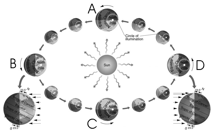
Answer: B
16) Three criteria used for classification of the atmosphere explained in the text are
A) structure, origin, temperature
B) structure, origin, evolution
C) composition, origin, evolution
D) composition, temperature, and function
E) evolution, composition, and function
Answer: D
17) Temperatures within the stratosphere
A) decrease with altitude according to the normal lapse rate
B) remain about the same from the tropopause to the stratopause
C) increase with altitude because of the absorption of ultraviolet radiation
D) decrease with altitude due to radiation losses
E) increase due to radiation of heat from the surface of Earth
Answer: C
18) If a surface absorbs insolation,
A) its temperature increases
B) its temperature decreases
C) its temperature is unaffected
D) refraction occurs
E) diffuse radiation occurs
Answer: A
19) When water evaporates, the energy that was used to evaporate the water
A) is stored as sensible heat in the evaporated water
B) is stored as latent heat in the evaporated water
C) is transferred to the air by advection when the water evaporates
D) is conducted into the underlying layer of water
E) is convected into the atmosphere
Answer: B